

How does it look from space? Satellite surge to alter investing
Higher-frequency images set for use in entirely new ways and by more investors than before

Need to know
- Planned launches of hundreds of new satellites promise a flood of higher-frequency images, opening up new opportunities to keep an eye on the physical assets of companies.
- The new images will enable investors to monitor one-off events and projects, keep tabs on polluters as part of ESG investing, and extend the common practice of measuring stockpiles and traffic for insights into a market or a company’s finances.
- “Within 10 years, geospatial analysis will be part of financial analysis,” says Ben Caldecott at the University of Oxford.
- Robeco and Union Investment are among funds looking at what’s possible.
For funds forever looking for that elusive edge, even space is no longer the final frontier.
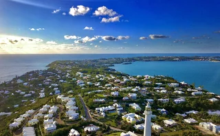
In what sounds like science fiction, hundreds of new satellites will zoom into orbit in coming years and start beaming down round-the-clock visual updates on unsuspecting companies. The hour-by-hour images of factories, mines, shopping malls and the like will boost the existing pool of so-called geospatial data – information gathered by satellites, as well as drones, aircraft, hot-air balloons and even self-driving cars.
Asset managers – including fundamental investors, many of which are unfamiliar with geospatial data – will be able to use these higher-frequency images in new and different ways from what’s been done before.
“Within 10 years, geospatial data and analysis will be an integral part of financial analysis – an acknowledged and regularly used skill,” says Ben Caldecott, an academic at the University of Oxford and the leader of several initiatives to promote the use of geospatial data in finance.
Experts see three broad applications for the expected flood of images: assessing the impact of events such as industrial accidents and strikes or monitoring specific projects; identifying polluters and other kinds of environmental ‘bad citizens’; and expanding and refining existing practices, such as measuring stockpiles and counting cars in parking lots, for insights into a company’s health or supply-and-demand trends.
Geospatial data is potentially useful to all types of funds, but it is of greatest interest to fundamental investors, given their close focus on relatively few companies. Some funds, including Robeco and Union Investment, are already keeping an eye on their investments from space or actively looking into the idea.
While satellite images can’t answer every question investors have, they have distinct advantages over other data. Satellites can be investors’ eyes in the most hard-to-reach places around the world; the data they produce is free from sampling bias; and, unlike some other types of alternative data, images sent by the orbital spies come with fewer concerns about privacy.
“The use of geospatial data is totally in its infancy. [But] it is going to be a must-have for every single business, just like demographics data or customer transaction data today,” argues Tom Diamond, president of RS Metrics, which sells satellite images and geospatial analytics.
The skies have (more) eyes
The impetus for change comes from a big push to commercialise space.
The number of satellites capturing commercially available data has gone up from no more than 20 six years ago to 280 today, according to research by Steve Wilcockson of Geospatial Insight, a geospatial analytics firm. The company estimates there will be 500 by the end of 2020 and 750 by 2022.
RS Metrics sees a similar trend. The vendor processes images from about 20 high-resolution satellites – a number that will jump to hundreds next year, says Diamond.
The effects of such a vastly expanded satellite network will be palpable. While at present investors can see images of a location about once a week on average, “next year that’s going to be every single day for every location on Earth”, predicts Diamond. “The year after that, it will be multiple times per day.”
Already, there is value even in the comparatively small number of commercial images available today.
For instance, when a train owned by miner BHP and carrying 268 wagons of iron ore derailed in Western Australia in November last year, satellite imagery showed both how fast tracks were being cleared for other shipments and how far stockpiles at the train’s destination port were running down.
In another example of such accident surveillance, a hedge fund monitored images of a company’s mining facilities after regulators lifted a safety shutdown, to see how fast output would ramp up.
Satellite data vendors already sell analytics based on geolocation data from smartphones cross-checked with satellite information to track the number of people on the ground at oil and metal refineries. Sudden upticks can be a sign of outages, which can impact the price of the commodity in question.
Satellites can even help investors be the first to know about disruptive events. It is rare that events such as the derailment in Australia are covered quickly by the media or show up on Twitter, says Abraham Thomas, chief data officer at Quandl, which provides alternative data including satellite images. Even when they do, information on social media is “completely unverifiable”, he notes. “Satellites can provide confirmation.”

And in some cases, satellites can detect the warning signs of an impending disaster.
Caldecott at Oxford University points to the deadly collapse of a dam containing liquid mining waste in Brazil in January.
“You could have worked out how risky the Vale mine in Brumadinho was by looking at mine waste seepage using satellite imagery,” he says. “You could do the same thing for different mining companies and see who has the biggest risks.”
Had a fund priced in the growing risk to the dam and foreseen the subsequent mine closures, it might have been better-positioned for the spike in the price of iron ore that followed the disaster.
Cops in space
The second way to unlock the potential of satellite images is to apply them to environmental, social and governance (ESG) investing. It is a booming area, and satellite images can help with what can be called environmental policing of investments, especially in far-flung places.
“A frontier market in southern Africa or Latin America is no harder for a satellite to get to than suburban London or Palo Alto, California,” says Kevin O’Brien, chief business officer at Orbital Insight, a seller of geospatial analytics.
Global sustainable investing assets stood at more than $30 trillion at the start of 2018, according to the most recent report from the Global Sustainable Investment Alliance, which promotes ESG investing. And MSCI estimates that over the coming 20–30 years, millennials will put up to $20 trillion into US ESG funds alone.
Katherine Glass-Hardenbergh, an associate portfolio manager at quantitative asset manager Acadian, says she expects “continued and growing” interest in using satellites for ESG insights, particularly in measuring the impact of climate change and severe weather events, as well as measuring carbon footprint.
The idea of using geospatial data to help in ESG investing appeals to Union Investment, a €320 billion-plus ($357 billion) German asset manager, which started ESG investing as far back as 1995 and boasts more than €40 billion in specialist ESG funds.
“We don’t use geospatial data – yet,” says Henrik Pontzen, the firm’s head of ESG. “But we are ready and we are actively searching for ways to do so.” He estimates the firm will begin using the data by the end of next year.

As part of its preparation, Union has hired a specialist into its ESG team of 11 to look at what is available and how it can be incorporated into the firm’s investment models. The principal value is in validating data obtained from “non-independent” sources, Pontzen says. This could mean cross-checking, for instance, what the company of interest to a fund says about its ESG credentials.
Pontzen gives the example of BP’s 2010 Deepwater Horizon oil spill: if it occurred today and Union Investment were using satellite data, it would not have to rely on media coverage and statements from BP about the scale of the damage.
In the Netherlands, Robeco is starting to use satellite data to monitor companies in which it is an activist investor, for example to check on deforestation rates where Robeco invests in palm oil producers. Likewise, Investec Asset Management is exploring the use of satellite data to measure deforestation and is planning to publish a report on the topic in the summer.
In addition, Robeco wants to “encourage companies to start using this type of data [themselves] to increase the speed and accuracy with which they act on red flags”, says Carola van Lamoen, who heads Robeco’s active ownership team.
Satellite images could also be used by investors to put pressure on polluters. In this vein, the Investor Mining and Tailings Safety Initiative, which brings together institutional investors active in extractive industries, is looking into the use of satellite data to monitor the safety of dams containing hazardous mining waste.
As part of the initiative, 96 institutional investors wrote to 683 extractive companies in April seeking greater disclosure on the management of storage facilities for mining waste. The measure was triggered by the collapse of Vale’s Brumadinho dam, which led to more than 300 deaths.
Counting, on rocket boosters
The third way of using satellite images builds on a relatively common practice of tracking stockpiles, traffic and other recurring indicators of a company’s finances and of trends. One well-known example involves counting cars in the parking lot of a retail outlet to assess its fortunes month to month. An extension of this practice would be to compare parking lots at retail outlets close to each other to gauge which company is winning market share.
One hedge fund has already done something similar: using satellite images, it has monitored the traffic in airport car hire parking lots for a steer on how much business those firms were losing to Uber.
Meanwhile, an activist investor has used satellite data to monitor store traffic for a retailer – to work out which stores it should press the retailer to close.
And investors in commercial mortgage-backed securities and real estate investment trusts have bought RS Metrics data on retail traffic at shopping malls and other commercial buildings to help quantify the credit risk of the underlying properties backing those securities, says Diamond, the firm’s president.
In their search for new information, funds are nothing if not creative.
“We get idiosyncratic queries on a weekly or fortnightly basis – some quite odd in nature and some very specific in geographical scope,” says Wilcockson at Geospatial Insight. Long-only managers and non-financial companies are joining hedge funds and insurers in their interest in what the data can reveal, he adds.
As interest in satellite images grows and more of them become available, satellite data firms are expanding their offerings. For example, they no longer measure just how much oil is being stored but also the size of stockpiles of metals, such as copper, tin, aluminium and zinc, piled up outside smelters or ports, while RS Metrics measures stockpiles of lumber.
In yet another example of an unusual offering of satellite images, Diamond points to First Solar which installs solar panels. “They get paid when the panels are hooked up and installed, not just when they are delivered to the location,” he says. “By tracking the pace of panel installations with imagery, we are literally looking at their cashflow.”
New space age
The looming launch of hundreds of new satellites promises an explosion in these kinds of next-generation spatial analytics. The next step will be their wide adoption in finance.
So far, new applications of satellite images are niche activities. Only about 20 hedge funds use the data in ways more complex than trading on fairly standard commodities storage signals, according to Thomas at Quandl.
Any investor serious about extracting value from the images needs to hire specialists including in fields such as machine learning to help spot patterns in big complex datasets, he says. “If you gave 25 terabytes of data to the average investor, they simply wouldn’t know what to do with it.”
In many cases, the effort is likely to pay off – not only because satellites can see what can’t be easily observed in any other way, but also because of the data’s more technical characteristics.
For one, it is less likely to expose investors to regulatory fines and private lawsuits over breaching privacy. The US imposes a maximum resolution on the images that can be captured, which means a single pixel in a satellite image equates to the size of a football on the ground. By contrast, the risk of anonymised credit card data being re-identified continues to deter some investors from using it.
Satellite image data is free of any sampling bias, too. For example, credit card data reflects only a slice of purchases at a retailer because it doesn’t include cash purchases or because not all banks share that data.
This stuff is not pixie dust. It’s not out of the pages of Scientific American. It’s happening right now
Kevin O’Brien, Orbital Insight
With future use cases in mind, Orbital Insight is rolling out a web-based product – Orbital Insight GO – that lets users run the company’s off-the-shelf object-counting algorithms on “areas of interest” they are able to designate themselves.
“If you want to go and track a Volkswagen plant, you can either access the location from GO or use a customer-defined latitude/longitude of the plant. After simply drawing a bounding box around the plant, you can run a car counter on the location for the next three weeks and ask GO to send you an alert whenever there is a change of more than 2%,” says O’Brien at Orbital Insight.
RS Metrics, meanwhile, is working with index providers and issuers of exchange-traded funds (ETFs) on a range of ETFs to be launched in the next year. These will invest in metals futures, or manufacturing or retail stocks, using the firm’s satellite data and analytics.
Caldecott at Oxford University is leading a project called the Asset-Level Data Initiative aimed at identifying who owns physical assets and which uses geospatial data. He says the initiative could be like a human genome project for all physical assets, such as commercial buildings, factories and facilities, creating a consistent, comparable and comprehensive database of assets, their characteristics and their owners.
In time, he hopes, such an inventory will let investors see how exposed companies are to different risks and force them to do something about it.
Whatever the outcome of those projects, satellite images are entering a new age of wider availability and usage in finance.
“This stuff is not pixie dust,” sums up Orbital’s O’Brien. “It’s not out of the pages of Scientific American. It’s happening right now.”
Editing by Olesya Dmitracova
Only users who have a paid subscription or are part of a corporate subscription are able to print or copy content.
To access these options, along with all other subscription benefits, please contact info@risk.net or view our subscription options here: http://subscriptions.risk.net/subscribe
You are currently unable to print this content. Please contact info@risk.net to find out more.
You are currently unable to copy this content. Please contact info@risk.net to find out more.
Copyright Infopro Digital Limited. All rights reserved.
You may share this content using our article tools. Printing this content is for the sole use of the Authorised User (named subscriber), as outlined in our terms and conditions - https://www.infopro-insight.com/terms-conditions/insight-subscriptions/
If you would like to purchase additional rights please email info@risk.net
Copyright Infopro Digital Limited. All rights reserved.
You may share this content using our article tools. Copying this content is for the sole use of the Authorised User (named subscriber), as outlined in our terms and conditions - https://www.infopro-insight.com/terms-conditions/insight-subscriptions/
If you would like to purchase additional rights please email info@risk.net
More on Asset management
Execs can game sentiment engines, but can they fool LLMs?
Quants are firing up large language models to cut through corporate blather

Pension schemes prep facilities to ‘repo’ fund units
Schroders, State Street and Cardano plan new way to shore up pension portfolios against repeat of 2022 gilt crisis

Fears of runaway risk on offshore reinsurance
Life insurers catch the eye of UK regulator for pension buyout financing trick
Hot topic: SEC climate disclosure rule divides industry
Proposal likely to flounder on First Amendment concerns, lawyers believe

‘Brace, brace’: quants say soft landing is unlikely
Investors should prepare for sticky inflation and volatile asset prices as central banks grapple with turning rates cycle
Trend following struggles to return to vogue
Macro outlook for trend appears to be favourable, but 2023’s performance flop gives would-be investors pause for thought

Start-up bond platform OpenYield prepares to launch
Start-up aims to give retail brokers the same electronic liquidity used by the professionals

Can machine learning help predict recessions? Not really
Artificial intelligence models stumble on noisy data and lack of interpretability

Most read
- Breaking out of the cells: banks’ long goodbye to spreadsheets
- Too soon to say good riddance to banks’ public enemy number one
- Industry calls for major rethink of Basel III rules